


Every year, mining operations across West Africa lose hundreds of millions of dollars to a problem that is entirely preventable: drilling boreholes in the wrong location. If you are a COO or Country Manager responsible for water supply at a mining site in Ghana, Guinea, or the broader West Africa region, this article addresses the single most expensive mistake in your operational budget — and the proven geophysical survey that eliminates it.
The Importance of Groundwater Exploration for Mining
Let’s establish the scale of the problem with precise numbers.
40–60%
Borehole failure rate without prior geophysical survey in West Africa
$80K–$500K+
Direct cost of a single failed borehole per attempt
$1.5M–$2.5M
Annual avoidable losses for a mid-size mining operation
Between 40% and 60% of all borehole drilling in West Africa without prior geophysical survey produce no usable water — or yields far below operational requirements. Each failed borehole costs an average of $80,000 in direct drilling expenses. On complex mining sites with deep targets or remote access logistics, that figure regularly exceeds $500,000 per well once you account for:
- Drilling rig mobilization and demobilization
- Casing, cementing, and wellhead equipment
- Operational downtime measured in months, not weeks
- Contract penalty clauses triggered by supply delays
- Re-mobilization costs for a second attempt
For a mid-size mining operation running 3–5 water boreholes per year, this translates to $1.5M–$2.5M in avoidable losses annually — capital that disappears into the ground without producing a single cubic metre of usable water.
These failures are not bad luck. They are the predictable outcome of drilling in geologically complex terrain without the data needed to make an informed decision. This is not a drilling quality problem — it is a data problem.
Why West African Geology Makes Unguided Borehole Drilling a High-Risk Gamble
Understanding why borehole failure rates are so high in this region requires a brief look at the underlying geology — because the terrain is fundamentally different from sedimentary basins where conventional drilling heuristics were developed.
West Africa sits on the Precambrian crystalline basement — a formation of granites, gneisses, and amphibolites that is largely impermeable. Productive aquifers do not form in continuous layers that can be intercepted anywhere along a vertical drill path. Instead, groundwater concentrates in three specific structural environments:
Tectonic fracture zones
Ancient fault movements have opened permeable channels in otherwise solid rock. These zones can be as narrow as 20–50 metres wide — invisible to surface observation or conventional ERT surveys.
Weathered basement — saprolite layer
The chemically degraded upper zone of the basement rock, where secondary porosity creates storage capacity. Thickness varies from 5 metres to over 80 metres across distances of hundreds of metres.
Paleochannels
Buried ancient riverbeds that preserve high-permeability sediment fills at depth. Entirely invisible to surface observation — only detectable through subsurface geophysical profiling.
Without geophysical survey data, a drill crew has no way to distinguish a productive fracture zone from a barren granite mass. The borehole location is effectively chosen by assumption — and in West African crystalline basement, assumptions fail 40–60% of the time.
The Geophysical Solution: Knowing Where the Water Is Before Any Rig Moves
The answer to unguided borehole drilling is structured groundwater exploration using multi-method geophysical survey — specifically the combination of Remote Resonant Spectral Sounding (RSS) and Nuclear Magnetic Resonance (NMR) ground verification.
This two-stage methodology — the same approach used by Geo Water Tech across 21 countries on 5 continents — transforms borehole siting from a probabilistic guess into an engineering decision based on measured subsurface data.
Stage 01
Remote RSS Survey — Territory-Scale Aquifer Mapping Without Site Disruption
Geodirect RSS technology processes analogue infrared satellite imagery using resonance spectral effects to directly detect underground water-bearing formations. The survey is conducted entirely remotely — no site visit, no logistics, no interference with active mining operations.
What RSS delivers:
- Location and lateral extent of productive aquifer zones, mapped to GPS coordinates
- Depth profiles of water-bearing horizons — verified to 300m+ in field deployments
- Identification of fault zones, paleochannels, and basement depth variations
- Survey coverage from a single drill site to tens of thousands of square kilometres
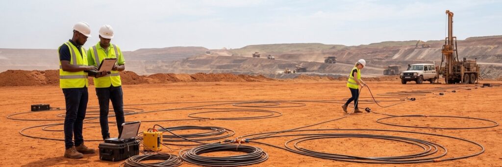
Stage 02
NMR Ground Survey — Drill-Point Verification Before Commitment
At the specific drill points identified by RSS analysis, Nuclear Magnetic Resonance (NMR) ground survey provides direct, quantitative measurement of subsurface water content. NMR is the only geophysical method that directly measures the hydrogen proton signature of water molecules — not an indirect proxy. Patented in Germany and Ukraine, tested in the USA.
What NMR delivers at each proposed drill point:
- Confirmed presence and depth of water-bearing horizons (aquifer)
- Estimated flow rate — litres/second or m³/hour
- Water quality classification: fresh, brackish, or mineralised
- Thickness of the productive horizon
- Elimination of false positives flagged at the RSS stage
The Deliverable: A Bankable Drilling Report
Upon completion of both survey stages, your operations team receives a complete drilling data package in English and French, including:
- GPS coordinates of recommended drill points, ranked by predicted yield
- Depth column profiles for each target horizon
- 3D subsurface deposit models
- Structural geology maps of the surveyed area
- Predicted flow rates and water quality indicators
- Full technical documentation for permitting and ESG reporting
The ROI Case: Survey Costs vs. Avoided Loss
The financial case for pre-drill geophysical survey is not nuanced — it is arithmetic.
| Item | Cost / Value |
|---|---|
| Geo Water Tech RSS + NMR survey (typical site) | 5–15% of single borehole cost |
| Single failed borehole — West Africa average | ~$80,000–$500,000+ |
| Avoided loss per borehole when failure is prevented | 100% of drilling cost recovered |
| Productive boreholes typically identified per project | 3–5 confirmed targets |
| Documented case: client saved by relocating drill point 340m | $1,000,000+ avoided loss |
A survey that costs $30,000–$60,000 prevents losses that regularly reach $250,000–$1,500,000 on a single project. The survey pays for itself the moment it redirects a single drill point away from a barren formation.
Beyond direct cost avoidance, the survey ROI extends into three additional dimensions:
Operational continuity
A confirmed productive borehole at the first attempt eliminates months of operational disruption. For mining operations where water supply is on the critical path to production, schedule certainty is a financial asset — not just an operational convenience.
ESG compliance documentation
IFC Performance Standards and Equator Principles — the frameworks governing most institutional mining finance in West Africa — require demonstrable evidence of responsible environmental impact management. A formal geophysical survey report provides exactly this evidence. It is a due diligence asset for your next funding round.
Investor and partner confidence
Presenting a groundwater development programme grounded in multi-method geophysical survey demonstrates operational maturity. It is a visible signal to equity partners and development finance institutions that your management team applies engineering discipline — not assumption — to capital expenditure decisions.
Field-Verified Accuracy Across West Africa and Comparable Geological Environments
Mauritania · Sahara Desert
Underground freshwater flow found where classical methods had failed
Area surveyed: 2,500 km²
Profondeur du puits : 75 à 150 m
Flow rate: 5 l/sec — confirmed by drilling
Water type: Fresh — matched survey data exactly
une précision de 100 %
Ethiopia · Danakil Desert
20 l/sec artesian well in one of Earth’s driest regions — first attempt
Area surveyed: 1,000 km²
Profondeur du puits : 190 m
Débit : 20 l/s (72 m³/h)
Résultat : un seul puits, première tentative — réussite
une précision de 100 %
Mongolia · Gobi Desert
Six productive wells in remote desert territory — 6/6 success rate
Area surveyed: 1,600 km²
Puits forés : 6 au total — tous couronnés de succès
Profondeur : 290 à 320 m
Débit : 20 à 25 tonnes/heure par puits
6 / 6 success
Gulf of Guinea · Offshore
Offshore platform survey — precise match with client’s existing subsurface data
2 plateformes offshore inspectées
Méthode : RSS à distance — aucun navire requis
Results matched client’s known data precisely
Adapté à l'exploitation offshore
Documented $1M+ save: A mining client was positioned to drill at a site that RSS analysis identified as outside the productive deposit boundary. The drill point was relocated 340 metres. Drilling confirmed the new location at 100% accuracy. The client’s own letter documents the avoided loss at over $1,000,000.
ESG, Community Relations, and the Cost of Unstructured Water Development
There is a dimension to borehole failure that rarely appears in direct cost calculations, but which is increasingly material to mining licence security in West Africa: community and regulatory relationships.
Multiple failed boreholes in a local area create visible evidence of environmental disruption — disturbed land, abandoned wellheads, potentially compromised shallow water tables — without delivering the water supply they were intended to produce. In communities where groundwater is a shared resource with significant cultural and practical significance, this pattern generates conflict.
Structured geophysical survey, with its defined methodology, formal documentation, and precision targeting, signals to communities and regulators that your operation approaches water development with professional rigour. The difference between “we drilled here and it didn’t work, so we’re drilling there” and “we conducted a comprehensive subsurface survey and identified the precise location of a productive aquifer” is not merely technical — it is reputational.
For mining operations navigating the increasing scrutiny of the West African regulatory environment, that reputational distinction has real licence-value.
How the Process Works: From Coordinates to Confirmed Drill Points in 3–6 Weeks
Free Preliminary Assessment — 48 hours
Send your site coordinates via WhatsApp or email. Within 48 business hours, our team provides an initial groundwater potential assessment based on satellite data — at no cost and no commitment.
RSS Remote Survey — 1–2 months
Our team initiates the full RSS satellite survey of your territory. No site visit required. Survey coverage is scaled to your project area — from a single drill point to 17,000 km².
NMR Ground Verification — on-site
At the highest-priority targets identified by RSS, NMR ground survey is conducted to confirm depth, yield, and water quality at each proposed drill point.
Drilling Report Delivered — EN + FR
You receive the complete data package — GPS coordinates, depth profiles, 3D models, flow rate predictions — in English and French, ready for your drilling contractor.
You Drill with Confidence
Your rig mobilises to confirmed targets. Our documented accuracy across 21 countries on 5 continents: 97–100%.